Route 4: Howden Moors, Derwent Reservoir, Peak District
Description:
Decent route with good advance views. Took me 5.5 hours for the full walk, which allowed something like an hour for sunning on rocks and puttering. Out of this I got 4 hours nude time and met no one.
As with Route 1, park up at the Fairholmes car park there are toilets here as well as a place to get some food. From here hike northeast under the Upper Derwent dam, then follow the reservoirs east side until you get to a turnoff just before the Howden dam. Here turn right onto the dirt track which ascends steeply. When you get to the first summit of Nether Hey, youll now be able to see the Howden Edge ridge rising in front of you usually it takes around 45 mins to get to Nether Hey.
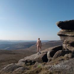
From this point on, you should be able to go boots-only. If you scan the ridge and cant see anyone coming down, probably there isnt anyone. People are fairly easy to spot if they are on the unmarked footpath just to the west side of Howden edge that descends and meets the path halfway up the hill at Row Top (most take this path). There is also the path marked on the map that goes to Row Top and then up the hill but from where you are now, you wont see if anyone is on that one. So just keep this in mind as you climb up to Row Top. From Row Top, take the main path towards Howden Edge but turn off on a faint track to the right about halfway to the top (not marked on the map) this leads towards some rock outcrops called Wet Stones. There are some grouse butts up here which are great for sunning yourself in if there is an easterly wind. The rock outcrops here are great for sunning yourself on and give you a great view of the valley and path in front of you.
From here follow the drainage lines past the rock outcrops in south/southeast direction youll find this leads to a path that leads east/southeast. After a short while (I think around Robin Hood Moss) when you see drainage patterns to your right, leave the path youre on and follow the drainage lines down the hill. When the drainage line peter out, keep to the right so that you have a good view of the valley on the right here youll pick up a path. Follow it down to another grouse butt (another great suntrap). At this point youll be able to see the clear track to the right on the other side that goes back to the reservoir (youll be walking back on that one). To get to it, you keep on the same path this takes you down the east side of Foul Clough to Abbey Brook. As you approach the stream, here is where you might meet people as there are 2 paths that meet here. After you cross the stream, turn right until you meet the main track.
From here turn right all the way back to the reservoir you should be able to do it nude until the gate just before the reservoir. Even though this is a fairly obvious track, there are decent advance views and no paths crossing, so fairly good.
(Note: alternative routes from here not yet tried would be when at Abbey Brook to turn left on the main track (i.e. south) towards Back Tor, or you can try to take the steeper path on the south side of Abbey Brook in east direction that takes you to join the Dukes Road path east).
Privacy score out of 10:
-Advance view (0 = wide expansive, 10 = forested and corners): 2
-Number of crossings (0-10): 2
-Number of people met during walk (0-10): 0
-Average score: 1.3 (very good)
What day of week, what time of year:
Mid-week, early June
So I tried this route on the worst possible day. A sunny Easter Saturday! It was very busy and the closest car parking spot was 1 hour walk away from the start of the walk. The main car park is 5 for the day (you don't need change). The quiet path is 2 miles from the start point. So I might take my bike and cycle to the "real" start point and chain my bike to the fence. I wasn't able to hike naked as there was almost always someone in sight. I did manage two naked sandwich breaks by just leaving the path and finding a quiet hollow. At first I thought it was very empty so I did try and take a naked photo only to be seen by a couple. Unfortunately the woman seemed pretty angry about it., but she failed to get her husband to reprimand me. By about 5.30 everyone was gone, so I could relax and take some photos. I could have walked naked at this point but sadly I was feeling a bit too cautious. It a beautiful walk, but I found the map reading too difficult for me. Progress was very slow as I was taking ages map checking and in the end I was unable to complete the walk. I had to U turn and go back the way I had come.
I did this walk on Friday last week with a friend of mine, and we both really enjoyed it. The weather was changeable, especially in the morning, with wind blowing from the west. When the sun was out, it was lovely though! And after 13:00 there were also less clouds. There were many cars and people at all the car parks, but there weren't many hikers around, not even along the Derwent reservoir. We encountered only 7 other people in total on the trail. We had lunch on Howden Hedge, and here is where we ancountered 6 other people, who were going on along the Howden Hedge trail. We disrobed at the Wet Stones, and it was very windy but we had now turned our backs to it. We followed the path/drainage lines until the Foul Clough - luckily I had downloaded the trail on my phone! there was in fact no clear path, nor an easy way down through moors. I think we followed one of the sheep's paths down towards the Abbey Brook, and we had a little adventure getting there, but at the end we found a very protected and sunny spot by the valley stream, surrounded by beautiful waterfalls. We stopped here for a bit and even soaked our feet in the (very!) cold water. We then crossed over and joined the other path, and were chasing away the sheep on the trail. Here we met one other hiker with her dog, and we dressed up completely, thinking we were closer to the reservoir and we may meet others too - there was still no one until we came down the path along the reservoir! And sadly we did not bring a sarong or quick-to-wear shorts... next time we will!
With all these stops, it took us 5 h and 40 mins to and back the car park, with a total of 9.40 miles hike and a 2239 feet climb.
The weather looks loevely from tomorrow onwards, hope someone will enjoy this trail soon!
Actions
Back to TopicsReply to TopicShare this topic


Get paid just by sending us users/traffic.
Signup takes seconds, start now!
Signup as an affiliate!