When is the island typically accessible?
RE:When is the island typically accessible?
Yeah, the rains went on forever this year so it's taking time for the river water level to go down.
The best way to check (without driving out there) is to look at the Bonneville Dam Water level (Just google it)
https://waterdata.usgs.gov/nwis/uv?site_no=14128870
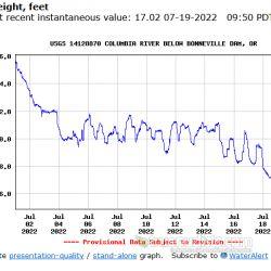
When the water level is at 15 feet you can wade out to the sand island. The water level was at 30 feet a few weeks ago and the water was all the way up to the parking lot clothing optional sign....
When the water is at 12 feet you can usually walk to the sand island with minimal wading. This is the graph for the last few weeks to today. The water is at 17 feet and falling.
This post was edited

Show 1-5 of 5
Actions
Back to TopicsReply to TopicShare this topic


Become an Affiliate
Get paid just by sending us users/traffic.
Signup takes seconds, start now!
Signup as an affiliate!