Angel Falls
Bass Lake, CA United States
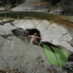
Explore Angel Falls - A Naturist's Paradise at Bass Lake, CA Hidden within the serene landscapes of Bass Lake, California, Angel Falls beckons the adventurous naturist. Known for its breathtaking cascades and tranquil surroundings, this spot offers a unique opportunity for those in the nudist...
About
Angel Falls
Off of CA Rd 274Bass Lake, CA United Stateshttp://friendsofangelfalls.org/index.phpAbout Angel Falls
Explore Angel Falls - A Naturist's Paradise at Bass Lake, CA
Hidden within the serene landscapes of Bass Lake, California, Angel Falls beckons the adventurous naturist. Known for its breathtaking cascades and tranquil surroundings, this spot offers a unique opportunity for those in the nudist community seeking a clothing-optional experience. Angel Falls has a rich history as a beloved destination for those who embrace the naturist lifestyle, including FKK enthusiasts.
The trail to Angel Falls, while offering stunning views and a peaceful retreat, does require some caution due to its slippery rocks. Naturists flock here to enjoy the sun and natural beauty in a state of total freedom, surrounded by like-minded individuals. It's important to note that while Angel Falls has been known as a nude-friendly location, visitors should always check current local regulations regarding clothing-optional use to ensure compliance and respect for all visitors.
Amenities are rustic, emphasizing the natural environment. As you explore, you'll find that the emphasis here is on experiencing nature in its most pure form. Whether you're a seasoned naturist or a curious newbie, Angel Falls offers an inviting, judgment-free zone to connect with nature and like-minded individuals.
So pack your essentials, leave your inhibitions (and perhaps your clothes) behind, and come discover the liberating experience of Angel Falls at Bass Lake.
Angel Falls Directions
From Fresno take Highway 41 north. After you drive through Oakhurst it is about another two miles and you will turn right on Rd. 222, that is the Bass Lake turnoff. Go a few miles and always stay to the left. It will turn into the high road of Bass Lake which is Rd. 426. You will pass by the Mountain Government Center on your left. The Falls is about another 1/4 mile. If you go over a bridge over water, you have gone too far. You will be going into a little driveway on the left with a steel fence and dirt driveway to the parking lot. Park down there near the river. Hike up the left side of the river on the trail. Look for pool just below Angel Falls