Garrapata Beach
, United States
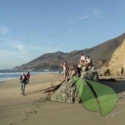
Welcome to the serene Garrapata Beach, a favored destination for naturists and those who cherish the freedom of a clothing-optional experience. Nestled along the picturesque coast, Garrapata Beach offers a tranquil retreat for anyone looking to escape the confines of everyday attire. As a...
About
Garrapata Beach
United StatesAbout Garrapata Beach
Welcome to the serene Garrapata Beach, a favored destination for naturists and those who cherish the freedom of a clothing-optional experience. Nestled along the picturesque coast, Garrapata Beach offers a tranquil retreat for anyone looking to escape the confines of everyday attire.
As a well-known spot in the nudist community, Garrapata Beach is celebrated for its stunning natural beauty and its welcoming atmosphere towards the FKK (Freikörperkultur) lifestyle. The beach's legal status as a clothing-optional area allows visitors to enjoy the sun, sand, and surf in the nude, fostering a sense of liberty and closeness to nature that is cherished by nudists and naturists alike.
Beyond its appeal as a nude beach, Garrapata Beach is equipped with basic amenities to ensure a comfortable visit. However, visitors are encouraged to bring essentials such as water, sunscreen, and towels. The area's management maintains a clean and respectful environment, making it a perfect spot for first-timers and seasoned naturists.
While basking in the freedom of Garrapata Beach, also take a moment to explore the surrounding flora and fauna, which enhance the beach's charm and allure. This location is not just a beach but a celebration of nature, freedom, and the nudist way of life.
So, whether you're a dedicated naturist or just curious about the clothing-optional lifestyle, Garrapata Beach offers a welcoming and beautiful environment to explore the joys of naturism. Embrace the freedom, embrace nature.
Garrapata Beach Directions
South of Carmel on CA 1 near milepost 63.1, shortly past the Garrapata State Beach sign Read how to interpret a California milepost marker
9.6 miles south of the Rio Road traffic light in Carmel
The house below is just beyond the parking area
Large parking area along the highway
The obvious trail leads to the middle of the beach. Near the beach, it forks
The left trail goes down to the middle of the beach and the right one follows the edge of the cliffs, eventually descending to a creek and the beach. This path could be dangerous when the creek is flowing strongly
The nude area is on the far north end of the beach