Gaviota Beach
West of Santa Barbara, CA United States
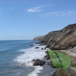
Welcome to the sun-kissed sands of Gaviota Beach, a premier destination for those who prefer their beach experience as nature intendedutterly nude. Nestled just west of Santa Barbara, this clothing-optional haven offers more than just a chance to free yourself from societal fabric constraints....
About
Gaviota Beach
CA Highway 101 around mile marker 44West Of Santa Barbara, CA United Stateshttp://gocalifornia.about.com/od/casexnudism/ss/sb-gaviota-nude-beach.htmAbout Gaviota Beach
Welcome to the sun-kissed sands of Gaviota Beach, a premier destination for those who prefer their beach experience as nature intended—utterly nude. Nestled just west of Santa Barbara, this clothing-optional haven offers more than just a chance to free yourself from societal fabric constraints. It's a place where you can bask under the California sun in your birthday suit, without the worry of tan lines or judgment.
Historically, Gaviota Beach has been a beloved spot for naturists and is known among the FKK (Freikörperkultur) community for its laid-back atmosphere and scenic beauty. While the legal status of nudity here can be as shifting as the sands, it remains a popular spot for those in the know. Just remember, while it's a place for freedom, discretion is advised to ensure it remains open and welcoming for all.
Aside from its liberating vibe, Gaviota Beach offers basic amenities such as restrooms and picnic areas, making it perfect for a day under the sun. Whether you're a seasoned nudist or a curious newbie, Gaviota Beach invites you to strip down to your essentials and enjoy a truly natural beach day.
So, if you're looking to shed your garments and your worries, Gaviota Beach is the spot. Just don't forget the sunscreen—some areas are more sensitive to sunlight than others!
Remember, Gaviota Beach isn't just a place; it's a state of mind. Strip away your cares and enjoy the freedom only a nude beach can offer!
Gaviota Beach Directions
North of Santa Barbara on US 101 before the refinery. Park along the road next to the Amtrak tracks, but don't leave your valuables in the car.
Driving Directions
https://gocalifornia.about.com/od/casexnudism/ss/sb-gaviota-nude-beach_3.htm
Near Santa Barbara, the California coastline runs east-west. It's one of the reasons for Santa Barbara's "banana belt" climate, but it can make giving directions confusing. According to the compass, Gaviota Beach is about 30 miles west of Santa Barbara, but according to the signs along the highway, you take US Hwy 101 north from Santa Barbara to get there.
If you're going north on US Hwy 101, it's a divided highway with no left turn to the parking area. You'll have to drive a few miles past it and make a u-turn. Exit at Mariposa Reina (exit #128) which is at the old refinery, follow the frontage road past the plant entrance, then turn left at the stop sign and left again to get back onto 101 going south.
About 3/4 mile after you get back on the highway, look for an informal, gravel-paved parking area. It's very shortly after you pass an emergency call box and mile marker 44. If you don't know how to read one, find out how to interpret a California milepost marker.
Walk across the railroad and down one of the paths. This is an active railroad, so it's a good idea to keep an eye out for trains.