Ocala National Forest
Ocala, FL United States
The Ocala is a unique and fascinating forest that offers an accommodating climate for year round recreating. The mild winters are fine for family camping while a summer canoe trip down a palm-lined stream is a cool way to spend an August day. The temperatures for the dry months of November through...
About
Ocala National Forest
Ocala, FL United Stateshttp://www.fs.usda.gov/ocalaAbout Ocala National Forest
The Ocala is a unique and fascinating forest that offers an accommodating climate for year round recreating. The mild winters are fine for family camping while a summer canoe trip down a palm-lined stream is a cool way to spend an August day. The temperatures for the dry months of November through February range from a daily average of 50 F to a high of 72 F. The summer season is much warmer and wetter. Short afternoon thundershowers often raise the humidity to about 90% while the temperatures range from 80 F to 95 F. The average rainfall is approximately 55 inches per year.
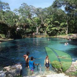
Water plays an important part in a variety of recreational opportunities on the forest. There are huge springs, twisting streams and lakes for fishing and water skiing. Many of the scenic lakes were formed when limestone bedrock dissolved, permitting the surface layer to slump and fill with water. The cool crystal-clear water of Juniper Springs, Alexander Springs, Salt Springs and Silver Glen Springs entice many visitors to take a cool dip. Snorkelers frequently find a thrilling underwater view of fish, swaying vegetation and cavernous springs. No wonder the Ocala National Forest is one of the most heavily used National Forests in the United States. Some recreational activities require a pass or permit.
Ocala National Forest Directions
The map coordinates are from Google Earth's location marker for the Ocala National Forest. There is no assurance that they are for a nudity-tolerant area.