Rodeo Beach
Marin County, CA United States
Welcome to Rodeo Beach, a serene nudist-friendly haven located in the picturesque Marin County, CA. Known for its distinctive pebbly sand and stunning ocean vistas, Rodeo Beach is a popular spot for those who embrace the naturist lifestyle, offering a clothing-optional experience in a natural...
About
Rodeo Beach
Bunker RoadMarin County, CA United StatesAbout Rodeo Beach
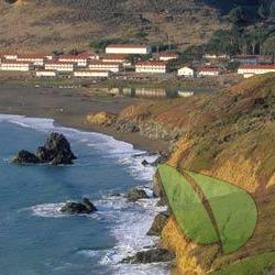
Welcome to Rodeo Beach, a serene nudist-friendly haven located in the picturesque Marin County, CA. Known for its distinctive pebbly sand and stunning ocean vistas, Rodeo Beach is a popular spot for those who embrace the naturist lifestyle, offering a clothing-optional experience in a natural setting.
Historically, Rodeo Beach has been a go-to destination for nude sunbathing and relaxation. While it's not officially designated as a nude beach, many visitors enjoy the freedom of naturism here, thanks to the beach's secluded location and laid-back atmosphere. It's important to note that the beach's status can change, so it's wise to check local regulations or with local nudist communities before visiting.
Amenities at Rodeo Beach include ample parking, picnic tables, and nearby hiking trails that offer breathtaking views of the Pacific Ocean and Marin Headlands. The beach is also dog-friendly, so it's a great spot for naturists who want to enjoy a day out with their furry friends.
Whether you're a seasoned naturist or exploring the clothing-optional lifestyle for the first time, Rodeo Beach offers a welcoming and scenic environment to connect with nature and like-minded individuals. So pack your sunscreen (and maybe a towel), and get ready to experience one of the most beautiful nude-friendly locales on the California coast!
Remember, at Rodeo Beach, the spirit of freedom and natural beauty invites you to shed your worries along with your clothes!
Rodeo Beach Directions
On the north side of the Golden Gate Bridge
Take the Alexander Road exit
Turn left at the end of the ramp onto Conzelman Rd
Follow Conzelman until it becomes two-way again
Turn right at the lighthouse turnoff
Rodeo Beach is at the end of Bunker Road
On the west (ocean) side of the lot
The path to the beach leads downhill to the left past a No Fires sign
Some find the path hard because of its mix of rocks and sand