Verde Hot Springs
Fossil Creek, AZ United States
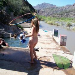
Escape to the serene embrace of Verde Hot Springs, a hidden gem nestled in the heart of Fossil Creek, AZ. This picturesque naturist haven is perfect for those who celebrate the clothing-optional lifestyle. Historically, Verde Hot Springs was a luxurious resort until it burned down in the 1960s,...
About
Verde Hot Springs
Fossil Creek, AZ United StatesAbout Verde Hot Springs
Escape to the serene embrace of Verde Hot Springs, a hidden gem nestled in the heart of Fossil Creek, AZ. This picturesque naturist haven is perfect for those who celebrate the clothing-optional lifestyle. Historically, Verde Hot Springs was a luxurious resort until it burned down in the 1960s, leaving behind the warm, mineral-rich waters that naturists continue to enjoy today.
The springs are accessible via a scenic trail that promises an invigorating hike before you unwind in the soothing waters. Embrace the spirit of nudist culture in these tranquil pools, where the only attire required is your smile. The area around the springs offers a lush backdrop, ideal for reconnecting with nature in its purest form.
As a respected naturist location, Verde Hot Springs maintains a respectful and inclusive atmosphere. It's important for visitors to adhere to the ethos of body positivity and freedom that FKK enthusiasts cherish. While the springs are on public land, they are known to be a safe space for nude recreation, aligning with the principles of many nude beaches and clothing-optional resorts.
When planning your visit, remember to respect the natural environment and the privacy of other visitors. Verde Hot Springs is not just a place to visit; it's a destination where you can truly be yourself, immersed in the healing waters of nature.
So, shed your garments and your worries at Verde Hot Springs, where the water is warm, and the welcome is always open. Here, you're not just visiting a location; you're joining a community.
Verde Hot Springs Directions
Directions to Hike
From Phoenix, travel north to Camp Verde. Get on the 260 heading east towards Payson. Go to forest rd 708. Drive to forest rd 502 turn right towards Childs.
Once you get to the last cattle guard at the Childs power plant the road gets pretty rough after this point, cars should park at the top.
From the campground, there is a road across the river, cross here (the water is only waist deep in the summer time).
You pick up the trail to your right once you cross the river. Travel down the trail about half a mile to the second crossing. The water current can be quite strong here after a good rain. Continue down the trail until you see a line of rocks crossing the trail, turn left, in about 50 feet or so you will see the river and the hot sprins on the other side. You can cross here (the water can be rough and deep after a good rain) or continue up the river along the rock banks, you will see a big pool at the end of the island, cross toyour left. Th trail continues behind the big tree up along the mountain. Enjoy.